| Current: |
 79.1°F
|
| Last Hour: |
0.9°F
|
| High 3:50 PM: |
87.7°F
|
| Low 2:48 AM: |
53.5°F
|
| Record High: |
133.2°F on
7/1/2018 |
| Record Low: |
-20.2°F on
3/16/2017 |
| Wetbulb: |
81.7°F
|
|
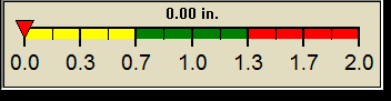
Rain Today
|
|
Today:
|
0.00 in
|
| Yesterday: |
0.00 in
|
| Last 7 Days: |
0.00 in
|
| Apr Rain: |
0.04 in
|
Apr to Date
Avg:10
|
0.00 in
|
Apr to Date
Diff from Avg:10
|
0.04 in
|
| Apr Avg: |
3.28 in
|
| Diff from Avg: |
 3.24 in 3.24 in
|
| Season:1 |
0.130 in
|
YTD
Avg:11
|
0.00 in
|
YTD
Diff from Avg:11
|
0.13 in
|
Last Rain
Time/Date: |
03/01/2020
at 7:50 AM |
|
2 rain days in 2020 |
0 days in April
23 days since last rain |
|
| Current: |
S
3.3 mph
|
| 1Hr Average: |
Calm |
| Wind Run: |
51.93 miles
|
|
Wind Gust |
| Current: |
3.3 mph mph
|
| Today: |
17.0 mph 8:08 AM
|
| Month: |
25.3 mph
Apr-5 |
| Year: |
26.8 mph
Feb-6 |
| Record Gust: |
49.5 mph
9/11/2017 |
|
Sunlight:

12:51:00
+1:39
Min:Sec
|
|
Date must be before Mon, 13 Nov 2023 04:27:00 -0500 | |


